Main menu: Home Features 3D Maps User Guide Support Buy Now Disused Tube Blog

Tram Master App Released!

TramMaster

Tram Master

After several months of visiting all the Tram stops in and around Croydon, and drawing 3D maps of them all … our new app, Tram Master is out!

We’ve drawn 3D maps of all the tram stops on the network, so you can see at a glance the layout of the station, which end of the tram stop the exit is, along with where the steps, ramps and lifts are, showing you how accessible all 39 tram stops are.

Download Tram Master on the App Store today! We’ve discounted it by 25% for a limited time only after the launch!

TramLink Map

26 Apr 16

Tram Master Complete!

We polished off the last of our 3D maps of the Tram system yesterday (Wimbledon, below) which means we’re now ready to submit them all as part of the Tram Master App to the App Store! Tram Master shows the layout in 3D map style (as per Station Master) of all 39 stops on the Croydon tram network.

Wimbledon Tram Stop

Wimbledon Tram Stop

15 Mar 16

New Whitechapel 3D

Here ya go then, here’s the new 3D map for Whitechapel – where there’s a new entrance/exit at the western end of the station, and then from the back of the westbound platform there’s a new corridor and steps down to the southbound Overground platforms – which look like they’re going to be a permanent addition and not a temporary one!

The new 3D map will be released in the next update to Station Master.

Whitechapel 3D

Whitechapel 3D

21 Jan 16

New Station Master Version Out!

iOS 7 icon

iOS Icon

Station Master version 1.10.9 has been released in the last couple of days, with the following updates:

  • Tottenham Court Road is open again on the Central Line (New 3D map and exit data)
  • Area Map View improvements
  • Updates and corrections to the database
  • Stability and performance improvements
  • Other refreshed 3D maps – to give 349 in total including all 270 tube stations

Exit the Tube (our ‘exits only’ companion App) also was updated to contain the same exit data as Station Master.

15 Jan 16

Meet … Mapway!

Our exciting festive news which we’ve been working on for a while and can now be revealed is that we’ve teamed up with the nice people at Mapway. Formerly known as mxData, you might already have one of their Apps on your phone – The Tube Map App.

We’ve teamed up with them to provide some of the data (such as exits, and 3D Maps) that’s within Station Master so that the Tube Map app can have access to it as well!

And for people that have been asking us for ages “When will your App be on Android”, the great news there is that the Tube Map App (including the Station Master data from early 2016) is on the Android platform!

There’s more over on the Mapway pages with their press release, including “One of the features we’re especially looking forward to sharing with you, is the addition of accessibility information for London Underground stations. And this won’t be your usual step-free info, that’s for sure. Thanks to Station Master we’ll have all sorts of details about accessibility for wheelchair users, people with prams and even travellers with luggage! So you have a clearer view of how easy a Tube platform is to reach, depending on the situation”

We’re also working with them on other projects in 2016, which we’ll reveal at some point, but until then have a look at the Tube Map App if you don’t already have it, and Merry Christmas from the Station Master!

Mapway

Mapway

21 Dec 15

Last of the Overground maps

We’ve been slowly chipping away, adding 3D maps to the App … the last few that need mopping up are the original Overground stations, and we’ve finally got around to doing the complicated mass of stairs and lifts that is Crystal Palace! It’s one of our favourite, most beautiful stations – but it is a little complicated with multiple platforms.

The finished 3D map will be in the next update to Station Master.

Crystal Palace 3D Map

Crystal Palace 3D Map

17 Sep 15

Disused Tube App

Our new App is out … today! Introducing Disused Tube.

There are over 50 old Tube stations in London, and we’ve listed them all; where they are, why they closed, what you can still see today – along with a Disused Tube map, audio descriptions for each one, and also two walking tour maps that will guide you if want to to hit the streets on your feet and go and find them yourself.

You can download the App here (it works on the iPhone as well as the iPad – on which it looks great) and learn about where London’s disused Tube stations are!

(With huge thanks to to Mark Noad for the exclusive design of the Abandoned Stations Map, have a look at his website for other alternative tube map designs.)

Articles about this also over on Londonist, and Metro Online too.

Disused Tube Map

Disused Tube Map


24 Jun 15

Shepherd’s Bush Map

We submitted the latest version of Station Master to Apple for review yesterday – now with quite a few more 3D maps added of London Overground stations. We’ll probably get them all done just in time for when all the new Overground stations open at the end of May, and then we’re in a dilemma about what to do, and if we add them or not …

Anyway, Shepherd’s Bush has had its new map put in too, as it has a new entrance and footbridge at the northern end of the platforms, it now look like this …

Shepherd's Bush Overground

Shepherd’s Bush Overground

30 Apr 15

Tube Status at a Glance on Apple Watch

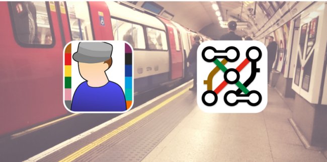
Your Apple Watch has finally arrived!  Oh, you’re still waiting too?

But when it does finally land on your wrist, you’ll be wanting something to tell you the state of the Tube at a glance won’t you!

Well, we have just the thing!  Visual Tube Status for Apple Watch!

VisualTubeBezel_42mm

The Apple Watch is all about (we believe) short (~5 second) interactions, called “Glances”.  Swipe up from the watch face and you can see a single screen of information at a glance.  We spent a long time thinking about how to quickly convey which lines were having problems and think we found the answer, with this target-cum-roundel-style graphic…

Watch Glance

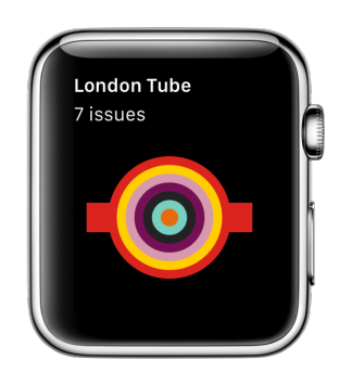
The Tube was obviously having a very bad day when we took this screenshot, but it shows the colours of the lines that were having problems.  In fact it was early on Sunday 19th April 2015 – the Central, Northern and Overground lines were on weekend closure for maintenance, the Circle, Hammersmith & City and Metropolitan lines were having Severe Delays and the Waterloo & City line was closed as usual.

But whatever’s going on, Visual Tube generates the image to show you the state of all the lines at the time you glance at it, so you’ll quickly know if there’s something you need to take into account on your commute.

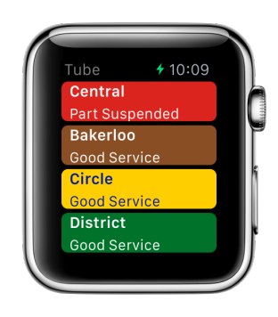
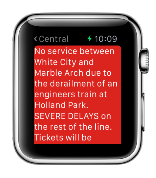
Want to know more details?  Tap the Glance on Apple Watch, and you’ll be taken to the lines view where you can see a more detailed list of the lines with the problem lines at the top.  Tap a line that’s not showing “Good Service” to see all the details.  This was Tuesday morning when the Central line had a derailment of an engineers’ train. (The Glance showed just a red symbol).

Watch LinesWatch Central Delay

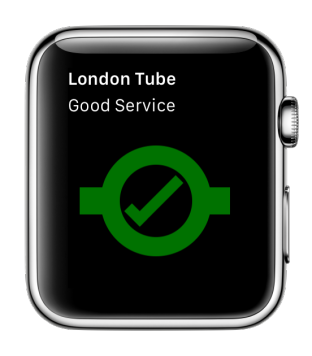
And on the (rare in the last couple of weeks) occasions when there is a “Good Service” you’ll be able to see the green tick.

Watch Glance Good Service

Head on over to the Watch App Store in the Apple Watch App on your iPhone to get hold of Visual Tube for Apple Watch (tap the search icon and search for “Visual Tube”).

(Visual Tube works on the iPhone and iPad too, but today’s all about the Apple Watch so we’ll tell you about those features another time!)

24 Apr 15

New Overground 3D Maps

With the prospect of new Overground stations being added to the official Tube map next month, it kicked us into gear a little when we realised that we still hadn’t finished and published all the 3D maps for the existing Overground stations on the network.  Hence, these last few days we’ve been busy designing them and will add them to the next release of Station Master – here Sydenham and its non-facing staggered platforms are clear to see!

Sydenham Station 3D Map

Sydenham Station 3D Map

Quite what we’ll do when the NEW Overground lines get added to the map is not clear. Will we add this info to Station Master or not? The jury is currently out and we’ll have to decide what to do …


17 Apr 15