Main menu: Home Features 3D Maps User Guide Support Buy Now Disused Tube Blog

Blanked Out

This weekend’s map fun comes in the form of a very geeky game that you can play with your tube-loving friends.

Print this out … the blank tube map, with all the stations removed!  Then in a way similar to “pin the tail on the donkey”, shout out some tricky station names, and the person playing has to point to where they think it is on the map. Oxford Circus, Earl’s Court and Baker Street are of course easy, but getting them to get totally correct places like Northwood Hills, Redbridge and Becontree suddenly becomes a lot harder!

Blanked Out Tube Map

Blanked Out Tube Map


08 Mar 14

If the truth be told

BuzzFeed who are normally so good at just propagating other people’s material, did something unusual this week – they created and distributed their own tube map variant, based on “What you would actually truthfully find at each stations…”.  Click on it for the larger version.

Truthful Tube Map

Truthful Tube Map

01 Mar 14

Trains on the brain

Some people have accused our minds of looking a bit like this … we can’t see it ourselves, personally… Heh.

Tube Brain

Tube Brain

23 Feb 14

Also Underneath

Another weekend, another alternative tube map from the archives – here we’ve found the ‘Underneath London’ map which shows the Northern Line (for comparison) underneath London, alongside the sewers, underground rivers, a bit of Roman London, and the Post Office Railway – which has recently been rumoured maybe will be opened up as an attraction to visitors in the near future, rather than being mothballed away.

Underneath London

Underneath London

15 Feb 14

Tube Waterways

It’s .. alternative map Saturday, which mean another delve into the large Station Master archives of alternative tube maps to see what we could find.

This weekend – this rather splendid map of London’s rivers – including some lost rivers, our favourite being the Westbourne which you can still see at Sloane Square station as it crosses above the station in a large pipe!

London's Waterways

London’s Waterways


08 Feb 14

Strike Wednesday (Afternoon Update)

2pm – Based on the latest information again from TfL we’ve updated our tube strike map. They are reporting that the Victoria Line is now running all the way to Brixton, and Central Line services now going all the way to Holborn, and round the Hainault Loop.

tube map 4 650

05 Feb 14

Strike Wednesday

9am – Based on the latest information from TfL, we’ve updated our map

Summary : No Bakerloo Line, Central Line is running to Ealing Broadway, the Piccadilly from is Acton Town only going as far as Hatton Cross – not Heathrow, Victoria Line is now going to Stockwell and some of the frequencies have changed for the better. The Bakerloo Line might open later in the day. The Northern Line is reporting a ‘Good Service’ !

strikemap650_3


05 Feb 14

Tube Strike Map

[See our post “Strike Thursday” for the latest Strike Map and information!]

With it looking increasingly likely that the tube strike is not going to be called off, Station Master has taken TfL’s list of tube services that it says it is hoping to have running, and turned it from a hard-to-understand list, into an easy-to-look at map – showing lines and stations that are opening with expected train frequencies in minutes.

Tube Strike Map

Tube Strike Map – Click for full size image

We’ll live update this on Wednesday and Thursday as/if and when the situation changes.

04 Feb 14

Mind the Cappuccino

After the alternative concept map last Saturday, this week a new variant! Maybe Saturdays will develop into the alternative-map-day, we’ll see.

So this was doing the rounds on the internet yesterday, created by Chris Ward who spends his working life in various coffee shops around London.    We can’t but help wonder if there will now be people who will go out and try and visit them all to say they’ve been to all of them.

Tube Coffee Map

Tube Coffee Map


01 Feb 14

Abandoned and Disused

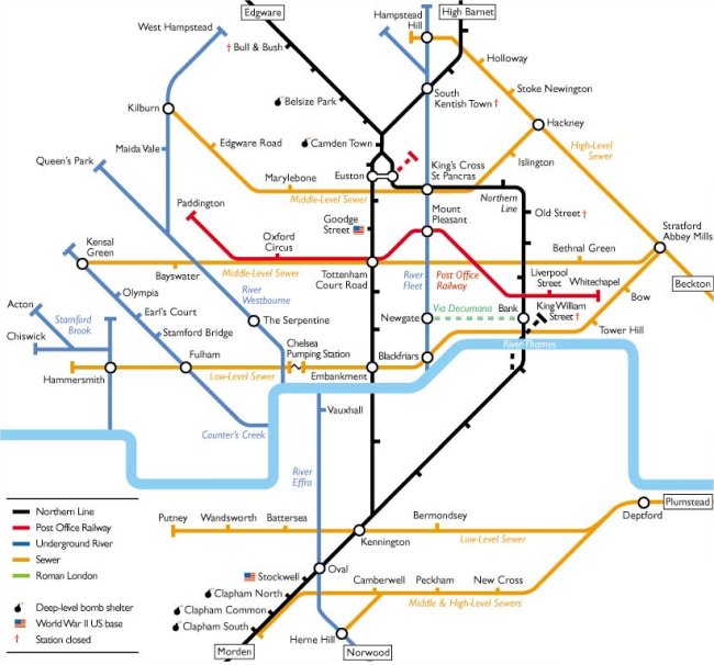
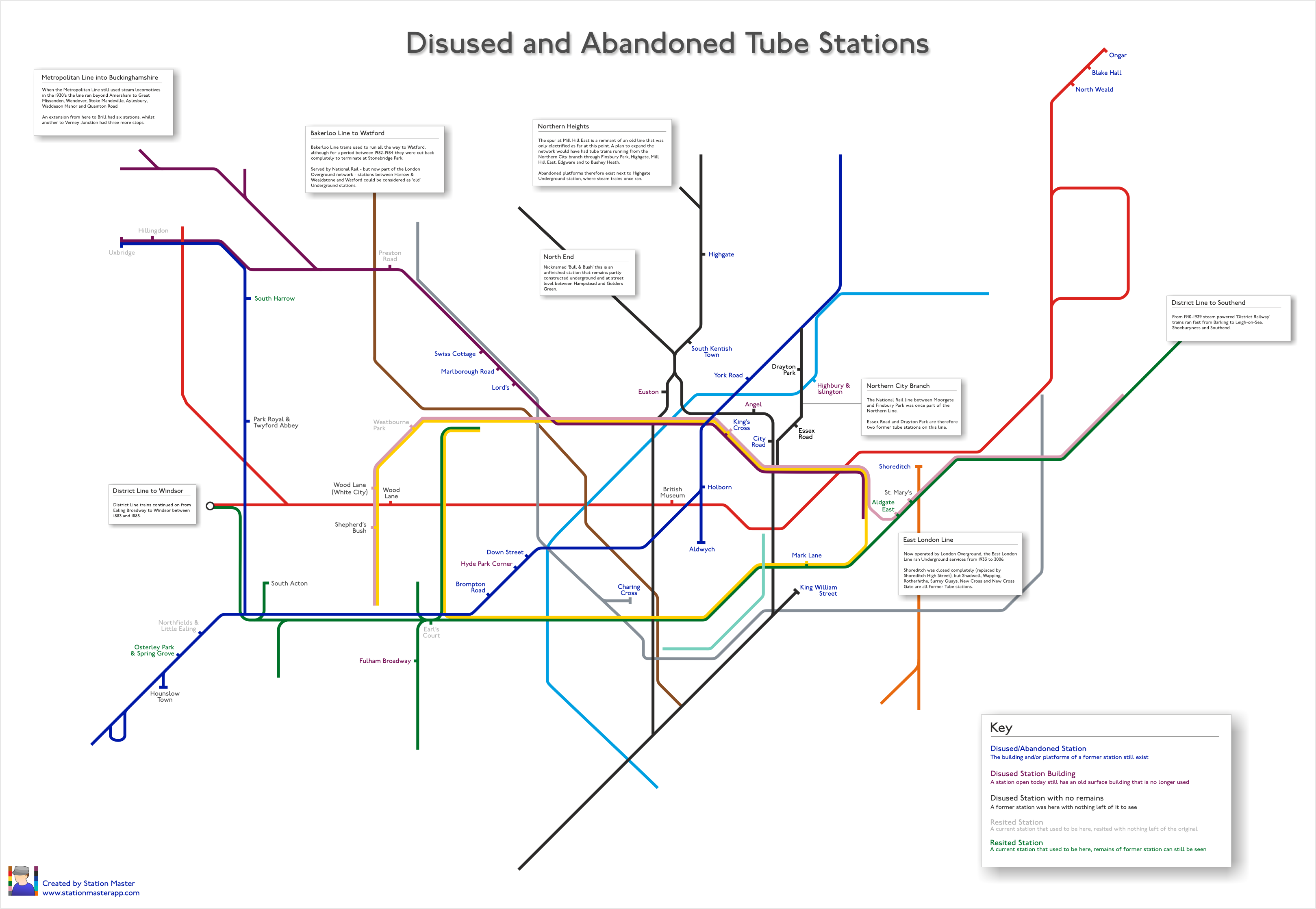
When the BBC ran a story a few weeks back on the allure of disused tube stations, they linked to a Ghost Station of the London Underground map which had us gasping slightly about various aspects of it.

First, it had used a version of the map that had the ELL dotted out whilst in ‘bus replacement’ mode, the zones had been left in, as had ugly connector blobs and blue-accessibility-blobs which just made it look ugly.  They even included the DLR, whilst missing the fact that there are a couple of resited stations on that too!

There was no clarity between what was a proper abandoned/disused station (e.g Aldwych) and what had been re-purposed as something else (e.g the Bakerloo Line stations up to Watford that became National Rail and now London Overground).

Also, there were some glaring errors with Grove Road and Uxbridge Road stations (in the Hammersmith / Shepherd’s Bush area) actually being London & South West Railway stations, and never part of the London Underground. They’d also missed out things like Hyde Park Corner and Euston having old abandoned surface buildings, which the ardent tube-geek might like to go and spot today.

So we made from scratch (drawn ourselves, not editing a current day version of the official map) our own version, a nice, clean, and accurate map of just disused and abandoned tube stations, showing everything – correctly – in the right place, with a key to help you distinguish between the different types.

Abandoned Stations

Abandoned Stations

With thanks to Bed Pedroche for his help.  Click on the image for the full size, it’s a large size image, and needs to be!

28 Jan 14