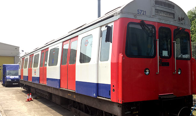
Main menu: Home Features 3D Maps User Guide Support Buy Now Disused Tube Blog

South Ken Colours

One of favourite facts on the Secrets of the District Line is that the colours painted onto the pillars at South Kensington tube station match the three lines that run there – Green, Yellow and Blue for the District, Circle and Piccadilly.

Even better is that Green was at the top and Blue at the bottom to match the fact that District is subsurface, and the Piccadilly is deep tube level down below.

Which is why why we found it disturbing to note that a couple of weeks ago they’d all been painted white … as a primer? Ok, maybe they’re just getting a new lick of paint, but now they’re starting to be painted at the green colour is now at the bottom of the pillars which is not where it was before!  We shall keep an eye on this closely to see what happens …

South Ken Coloured Pillars

South Ken Coloured Pillars

30 Jun 15

New Embankment Shops

The remodelling at Embankment station looks like it’s nearly finished, with two of the new three retail outlets, now open. We’re still reckoning that the third one will be an M&S Simply Food, but in the meantime there’s now a Paperchase and an Oliver Bonas … the latter of which we have never heard of before!

Embankment Retail

Embankment Retail

27 Jun 15

Disused Tube App

Our new App is out … today! Introducing Disused Tube.

There are over 50 old Tube stations in London, and we’ve listed them all; where they are, why they closed, what you can still see today – along with a Disused Tube map, audio descriptions for each one, and also two walking tour maps that will guide you if want to to hit the streets on your feet and go and find them yourself.

You can download the App here (it works on the iPhone as well as the iPad – on which it looks great) and learn about where London’s disused Tube stations are!

(With huge thanks to to Mark Noad for the exclusive design of the Abandoned Stations Map, have a look at his website for other alternative tube map designs.)

Articles about this also over on Londonist, and Metro Online too.

Disused Tube Map

Disused Tube Map


24 Jun 15

New Night Tube Map

A new Night Tube map has been released by TfL this morning … but it took a while for the correct version to come to the surface. When the Night Tube was announced last year, there was a map that came with it – a simple variation on the regular map with a white background showing the five lines that will be running.

A press release and story this morning announcing a ‘new’ Night Tube map, was using the same old map that had already been put out in September of last year. The Evening Standard ran with the existing version (calling it a ‘First Look’), until about an hour later, when it transformed into what IS actually a new Night Tube Map! Which looks like this …

Click Image for Larger Version

Night Tube Map

Night Tube Map

22 Jun 15

No Victoria Line during August

This one has been planned for a while now, but the carriage stickers in the trains have now all been updated to reflect that there will be no Victoria line between Seven Sisters and Walthamstow between the 8th and 30th of August.

The work is to allow a renewal of a crossover at Walthamstow which at the moment means only 24 trains an hour can run – after the works, the Victoria line will be able to run 36 trains per hour in the peak – that’s one every 100 seconds. You can read the full TfL Press Release here, but it does mean that once complete, more trains will run to Walthamstow too.

Replacement buses are running throughout the duration of the works, hence the pecked blue line on the carriage maps!

No Victoria line

No Victoria line

18 Jun 15

5721

Reports of C-Stock unit 5721 – which was preserved – being sold off to an East End Office and used as a waiting area, aren’t what they seem.  The unit is safe and sound at the Acton Depot …

The unit at the Relay Building has had the number ‘5721’ painted on it (in non standard font) but isn’t the preserved unit! And everyone calm down …

Unit 5721

Unit 5721

12 Jun 15

New Moorgate

The blue hoardings that have been up on the platforms at Moorgate station for ages finally came down this week to reveal new staircases, and a new entrance to Moorgate station. The old ticket hall entrance on Moorfields with its gateline disappeared ages ago, but now as part of the Crossrail works, it’s completely gone and been replaced with something temporary as a new enlarged ticket hall for Crossrail and the Metropolitan Line platforms is built here.

Here’s a shot of the temporary steps that take you down, and lead down to the eastbound sub-surface platforms, there’s another temporary staircase across a footbridge down to the westbound platforms.   There’s also a new entrance/exit out onto Fore Street – something that suspect shall be retained when the new Crossrail ticket hall opens.  We’ll have an updated 3D map shortly …

New Moorgate

New Moorgate

11 Jun 15

Pay for travel the Apple way

Apple Pay

Apple Pay

So with Apple confirming that Apple Pay is coming to the UK next month (July 2015), TfL confirmed in a press release that you’ll be able to use Apple Pay to travel on TfL services.

This means you’ll be able to tap your iPhone 6, 6 Plus or Apple Watch against a yellow Oyster pad, and pay for your travel that way.

“TfL was the first public transport provider to accept contactless payment cards and will continue this record of innovation by becoming the first to accept Apple Pay. TfL developed the contactless technology needed to travel on its services in-house and is leading the way with over 100 million contactless journeys made on its services since it launched in September 2014.”

TfL Press Release here. Lifehacker article.


09 Jun 15

From Pavement to Platform

We popped down (as all proper Tubegeeks do) to Studio Egret West in Farringdon yesterday to have a look at their exhibition ‘Pavement to Platform’.  SEW have won the tender from TfL and have created the ‘Design Idiom’ a  book setting the future design ethos for the London Underground.

Idiom Park Platform

If you want to go down and see their mockup of what a new Tube station will look like – they’ve created one called ‘Idiom Park’, and you can see the designs and talk to people who created them about setting the future design standards for the Tube. Their website and free tickets for the event are here.

We quite like their ‘design type map’ which they’d created too – showing across the underground network, which stations falled into which ‘catageory’ of design – Charles Holden stations for example were all in one colour, Leslie Green stations in another … it’s on the floor, so if you go down try not step on it!

Design Type Map

Design Type Map

05 Jun 15

How many stations on the Tube map?

New Tube map

New Tube map

So with a new Tube map in town, a Buzzfeed game has emerged with a blank map that tests your knowledge of where stations are on the Tube map (Not an original idea, this one has been around for much longer).

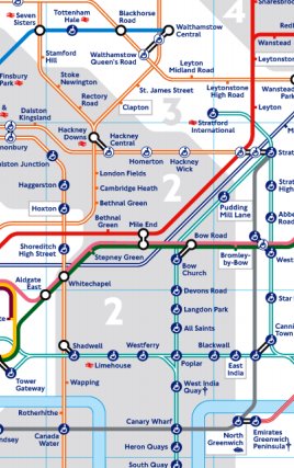
Of course ‘Tube map’ is a term that should be used lightly, as it’s no longer a Tube map – but a map of TfL services, so we should probably be calling it the ‘TfL Map’ instead.

But in that game they say that there are 401 stations – a figure that we disagree with as when the map came out last week, we had a count up ourself and had a different figure.

So we’ve counted them all up again this morning, and have come up with the same different figure – 408 in total – and so we’re going with that as the total number of stations on the TfL Map.

Here’s the breakdown:

Stations that are ‘pure’ and only have one mode

Tube – 243, Overground – 85, DLR – 41, TfL Rail – 10 

Then there are the stations that are ‘mixed’ – i.e. once though the barriers you have a choice

Tube + Overground : 23
(e.g. Richmond branch, Bakerloo up to Harrow and Wealdstone)

Tube + DLR : 3
(Bank, Canning Town, West Ham)

Tube+DLR+Overground+TfL Rail : 1
(Stratford)

Tube+TfL Rail+Overground : 1
(Liverpool Street)

TfL Rail + Overground : 1
(Romford)

And that’s 408 in total.

(Note – To determine what is a station, we go by the gateline/ticket barriers at that station. So on the map Paddington is shown once, but is actually two stations.  Hammersmith is also two separate stations. Shepherd’s Bush also has two separate gatelines for the Overground and Tube, and so it’s two separate stations, as is West Hampstead.  Shadwell is also separate stations – one for Overground, one for DLR.)

So back to our original thought – only 270 stations on the map are actually Tube stations – out of 408 now, is two thirds – 66.1% of the map. The rest is non-Tube.

Also – we didn’t include the two Cable Car ‘stations’. We can tell you’re gutted about that.

Incidentally – The best Tube map quiz that we’ve ever encountered is the still this fiendishly difficult one over at Sporcle – where you have to identify the 50 most popular words on the Tube map in just ten minutes, and we here at Station Master have never been able to get all 50!

03 Jun 15