Main menu: Home Features 3D Maps User Guide Support Buy Now Disused Tube Blog

New tube map

There’s a new tube map out for December 2013 (No interchange at Embankment for Bakerloo or Northern Lines!), and as with all new tube maps, there’s a new piece of artwork for the cover, this time designed by Imran Qureshi who’s work is “underpinned by his interest in and reflection on the relationship between ancient, traditional life and contemporary life in Pakistan as well as the complex relationship between Islamic and Western life and culture”.  Read more on that over on the Art on the Underground website.

Tube Map Cover December 2013

Tube Map Cover December 2013

19 Dec 13

Shortest travelling times between stations

We were out with our stopwatch on the Tube yesterday, testing whether the reported ’37 seconds between Covent Garden and Leicester Square’ really was true – and it is. On average that’s the time it takes between the doors closing at one station and opening at the other.

So we compiled a list of all the other shortest hops between two Tube stations, where journey times are all under 60 seconds. Try never to buy a cash fare ticket between these two stops!

These are all average timings from multiple journeys made going in both directions.

On the Piccadilly Line, Leicester Square and Covent Garden are the two closest stations together on the network with an average journey time of just 37 seconds.
Southwark to Waterloo on the Jubilee line takes on average 41 seconds.
The time between Charing Cross and Embankment (Northern) is 42 seconds.
Mansion House to Cannon Street (District and Circle) : 46 seconds.
Northfields to South Ealing on the Piccadilly are so close to each other you can see the other each from the the other one looking down the line. Journey time is 47 seconds.
The time between Charing Cross and Embankment (Bakerloo) is 48 seconds.
Holborn to Chancery Lane on the Central takes 50 seconds.
On the Central Line, Oxford Circus to Tottenham Court Road takes just 52 seconds.
Cannon Street to Monument (District and Circle) : 54 seconds.
Marylebone to Edgware Road on the Bakerloo, 55 seconds.
Bond Street to Oxford CIrcus on the Central takes 56 seconds.
Warren Street to Euston on the Victoria line takes 57 seconds.
Swiss Cottage to FInchley Road on the Jubilee Line is 58 seconds.
Shepherds Bush Market to Goldhawk Road on the Hammersmith & City, Circle Lines takes 58 seconds.

18 Dec 13

Edgware Road reopens Saturday

Edgware Road Lifts

Edgware Road Lifts

Publicity now being displayed suggests that Edgware Road on Bakerloo Line is scheduled to re-open on target ‘By the end of December’ – that date now being this Saturday, the 21st December.

It’s been closed for most of the year, to have its two old lifts replaced, which were only installed in 1992, just over twenty years ago.  The new lifts that have been installed are said to have a life-span of over of forty years.   So we’d like to warn you now of a future closure of Edgware Road station in 2053, to have its lifts replaced …

17 Dec 13

Future Transport Tube Map, 2021

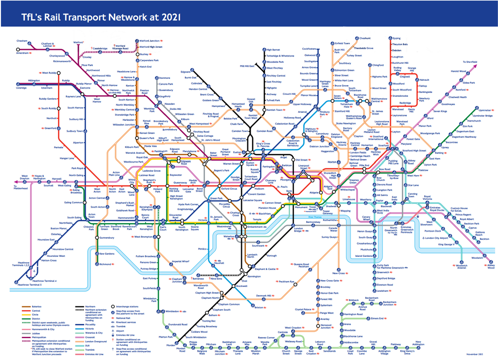
TfL produced a draft copy this week of what they think the tube map will look like in 2021.

2021map_650

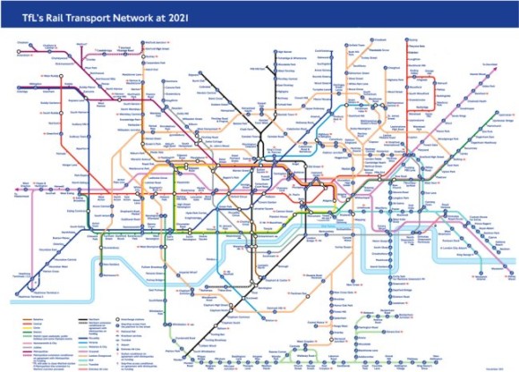
Obvious things to spot on there is Crossrail now spanning west to east across the map, the new Watford extension (with Cassiobridge and Watford Vicarage Road stations on the Metropolitan Line), the possible Northern Line extension (with Nine Elms and Battersea stations), but what’s new to appear on a proposed TfL map for the first time are the services out of Liverpool Street to Enfield Town, Cheshunt and Chingford.

It adds more spaghetti to the orange mess that is the Overground already the top right of the corner of the map is now looking most cluttered.

King-of-the-clutter though is still (of course) the patronising ‘blue blob’ of accessibility, and with the new Overground and Tramlink on the map (although, Tramlink always appears on proposed tube maps, but never makes the final editions) there are more blue blobs than ever – so much so we counted them up.

There are 222 stations that are ‘blue blobbed’ on this version of the map now, and just one more – 223 that do not!  So it’s almost at a 50:50 split.

So let’s apply some logic to this.  If 99% of stations on the map were step-free accessible you would obviously just mark (with a new symbol of some sorts?) the minority of stations which were NOT step free.   So – given that over time, more stations are going to become step free, at what point will TfL sensibly drop the blue-blob, and just highlight non-step free stations instead?

07 Dec 13

We won an award!

Metro article

Metro article

We’re delighted to be able to announce today that we’ve won an award! We’re one of four winners of the TfL Accessibility App competition which we entered back in August, and we won one of the prizes!

Station Master won the the ‘Best App for Accessibility/Step Free Information’ category, which after many many months of work that has gone into this (mainly involving private data surveys – e.g physically visiting all the stations ourself and counting the steps) feels great to an award and some recognition for this.

We should give a hat-tip to the other winners too which include Nearest Bus, Tube Tracker and the Colourblind Tubemap which are all worthy winners in their own categories.

Many thanks to everyone that has bought the App so far, left us reviews (good and bad!) and in particular those that have sent us feedback with their thought, suggestions and other such good stuff.

02 Dec 13